Page 2 - egyben_egyetemi_techn
P. 2
hnology Offer Flash-flood Risk Assessment Map
and Forecaster / Warning System
Keywords: flash-flood, risk assessment, GIS, forecast
Background
Field of technology: hydrology, soil science, GIS
Challenge: Occurrence and general characteristics of flash floods formed in the mountainous regions
of Hungary are profoundly influenced by the changing climatic conditions of the region. Other factors
like topography, soil, vegetation, are also important controls of runoff.
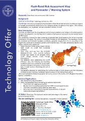
Brief descrip�on
Currently, we determined the (i) spatial and (ii) the temporal patterns and behavior of rainfall events in
Hungary and prepared a hazard map that is based on both passive and active environmental factors
(APFB model).
Our contribution involves the rapid screening of potential flash flood hazard in the hill and mountain
catchments of Hungary. The service is essentially founded on GIS databases. The databases include
the individual environmental boundary conditions, generally ranging from 0 to 5, according to the
degree they contribute to increased surface runoff of rainfall origin. The static (temporally stable or only
slightly variable) data applied are
• Digital Elevation Model (steep slopes indicate
rapid runoff; no runoff from horizontal
surfaces);
• Land cover, land use from the CLC2000
database (for inst ance, concrete surfaces
indicate high hazard as all rainwater feeds
runoff; foliage reduces runoff through
interception);
• Soil database: when establishing the runoff/
infiltration ratio, the following soil boundary
conditions have to be considered: (i) soil depth
(moisture storage in soil pores); (ii) soil texture
(clay or sand content, influencing the rate of
infiltration);
• Hydrography database for establishing the confluence sites of trunk streams and their tributaries
(confluences are of primary inundation hazard because of the impoundment effect)
„The most marketable intellectual property” winner at „Human in the Centre, 2012, Regional Innovation
Agency” competition.
Selected Applica�ons
1. Risk assessment map preparation
2. Water discharge/flash flood forecasting for selected catchments
• Flash-flood risk mapping (using GIS)
• Medium-term forecasting (using data from WRF meteorological model)
• Short-term forecasting (using observed radar data)
• Ultra-short-term nowcasting (using field measurements of soil and
hydrometeorological parameters)
IP Status: Know-how. The disclosed method and technology is fully owned
by the University of Pécs.
We are seeking for: Commercial partners, cooperation, license partners
Technology Transfer Office
University of Pécs
Vasvári Pál u. 4.
H-7622 Pécs, HUNGARY
www.innova�on.pte.hu
phone: +36 72 50 15 00 / 12292
mobile: +36 30 28 87 076
e-mail: k�k@pte.hu
All Intellectual Property rights reserved by University of Pécs
and Forecaster / Warning System
Keywords: flash-flood, risk assessment, GIS, forecast
Background
Field of technology: hydrology, soil science, GIS
Challenge: Occurrence and general characteristics of flash floods formed in the mountainous regions
of Hungary are profoundly influenced by the changing climatic conditions of the region. Other factors
like topography, soil, vegetation, are also important controls of runoff.
Brief descrip�on
Currently, we determined the (i) spatial and (ii) the temporal patterns and behavior of rainfall events in
Hungary and prepared a hazard map that is based on both passive and active environmental factors
(APFB model).
Our contribution involves the rapid screening of potential flash flood hazard in the hill and mountain
catchments of Hungary. The service is essentially founded on GIS databases. The databases include
the individual environmental boundary conditions, generally ranging from 0 to 5, according to the
degree they contribute to increased surface runoff of rainfall origin. The static (temporally stable or only
slightly variable) data applied are
• Digital Elevation Model (steep slopes indicate
rapid runoff; no runoff from horizontal
surfaces);
• Land cover, land use from the CLC2000
database (for inst ance, concrete surfaces
indicate high hazard as all rainwater feeds
runoff; foliage reduces runoff through
interception);
• Soil database: when establishing the runoff/
infiltration ratio, the following soil boundary
conditions have to be considered: (i) soil depth
(moisture storage in soil pores); (ii) soil texture
(clay or sand content, influencing the rate of
infiltration);
• Hydrography database for establishing the confluence sites of trunk streams and their tributaries
(confluences are of primary inundation hazard because of the impoundment effect)
„The most marketable intellectual property” winner at „Human in the Centre, 2012, Regional Innovation
Agency” competition.
Selected Applica�ons
1. Risk assessment map preparation
2. Water discharge/flash flood forecasting for selected catchments
• Flash-flood risk mapping (using GIS)
• Medium-term forecasting (using data from WRF meteorological model)
• Short-term forecasting (using observed radar data)
• Ultra-short-term nowcasting (using field measurements of soil and
hydrometeorological parameters)
IP Status: Know-how. The disclosed method and technology is fully owned
by the University of Pécs.
We are seeking for: Commercial partners, cooperation, license partners
Technology Transfer Office
University of Pécs
Vasvári Pál u. 4.
H-7622 Pécs, HUNGARY
www.innova�on.pte.hu
phone: +36 72 50 15 00 / 12292
mobile: +36 30 28 87 076
e-mail: k�k@pte.hu
All Intellectual Property rights reserved by University of Pécs